Science
Extreme high tides and winter storms magnified by sea level rise will result in more frequent and widespread coastal flooding.
The science and why it matters:
- With higher sea levels and occasional heavy winter storms, our shoreline communities will be more vulnerable to beach loss and coastal cliff erosion.
- Sea level in our region is expected to rise nearly three times faster between now and 2050 than it did in the prior half century.1
- In some parts of our region, we could see what is currently defined as a 1-in-100-year extreme coastal flood occur on an annual basis by 2050.2,3
- We will face greater likelihood of costly damage to coastal homes and businesses, as well as the port and airport, naval bases, highways and railroad tracks.
A word from the scientists
"Largest sea levels and impacts will probably occur when large winter storms coincide with high astronomical tides, especially during El Nino conditions. Low-lying areas such as Imperial Beach, Coronado, downtown San Diego, La Jolla Shores, Del Mar and the Oceanside Harbor appear to be particularly vulnerable. To enhance coastal resilience will require sustained monitoring and scientific investigation along with strong coordination that includes our local jurisdictions and public agencies."
Dan Cayan, PhD
Research Meteorologist, Scripps Institution of Oceanography, UC San Diego, and Oceanographer, Water Resources Division, U.S. Geological Survey

Sea level rise and coastal flooding
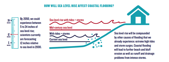
By 2050, we could experience between 5 to 24 inches of sea level rise; scientists currently are forecasting 12 inches relative to sea level in 2000.4
Sea level rise will be compounded by other causes of flooding that we already experience: extreme high tides and storm surges.5 Coastal flooding will lead to further beach and bluff erosion as well as runoff and drainage problems from intense storms.
1. Analysis by M. Tyree for NOAA Tides & Currents Station 9410230 (La Jolla). Data from NOAA Tides & Currents: http://tidesandcurrents.noaa.gov
2. Analysis by R.E. Flick for NOAA Tides & Currents Station 9410170 (San Diego Bay). Data from NOAA Tides & Currents: http://tidesandcurrents.noaa.gov
3. Chadwick, B., R. Flick, J. Helly, T. Nishikawa, I. Canner, P.F. Wang, M. Brand, A. Young, W. O'Reilly, P. Bromirski, W. Crampton, R. Guza, S. Boyce, M. Landon, M. Martinez, and B. Leslie, 2014. A Methodology for Assessing the Impact of Sea Level Rise on Representative Military Installations in the Southwestern United States, Strategic Environmental Research and Development Program final report for project RC-1703, February, 2014.
4. National Research Council. Sea-Level Rise for the Coasts of California, Oregon, and Washington: Past, Present, and Future. Washington, DC: The National Academies Press, 2012.
5. Diagram adapted from: Biging, G., and J. Radke, 2012: Coastal Flooding. In California climate extremes workshop report, D. W. Pierce, Ed., Scripps Institution of Oceanography, 32 pp.